
Monday, 1 May 2017
Guess the Planet 28: Bumps
Here is this week's guess the planet. What does this image show and which world does it depict?
 Check back on Friday for the answer!

Friday, 28 April 2017
Antarctica
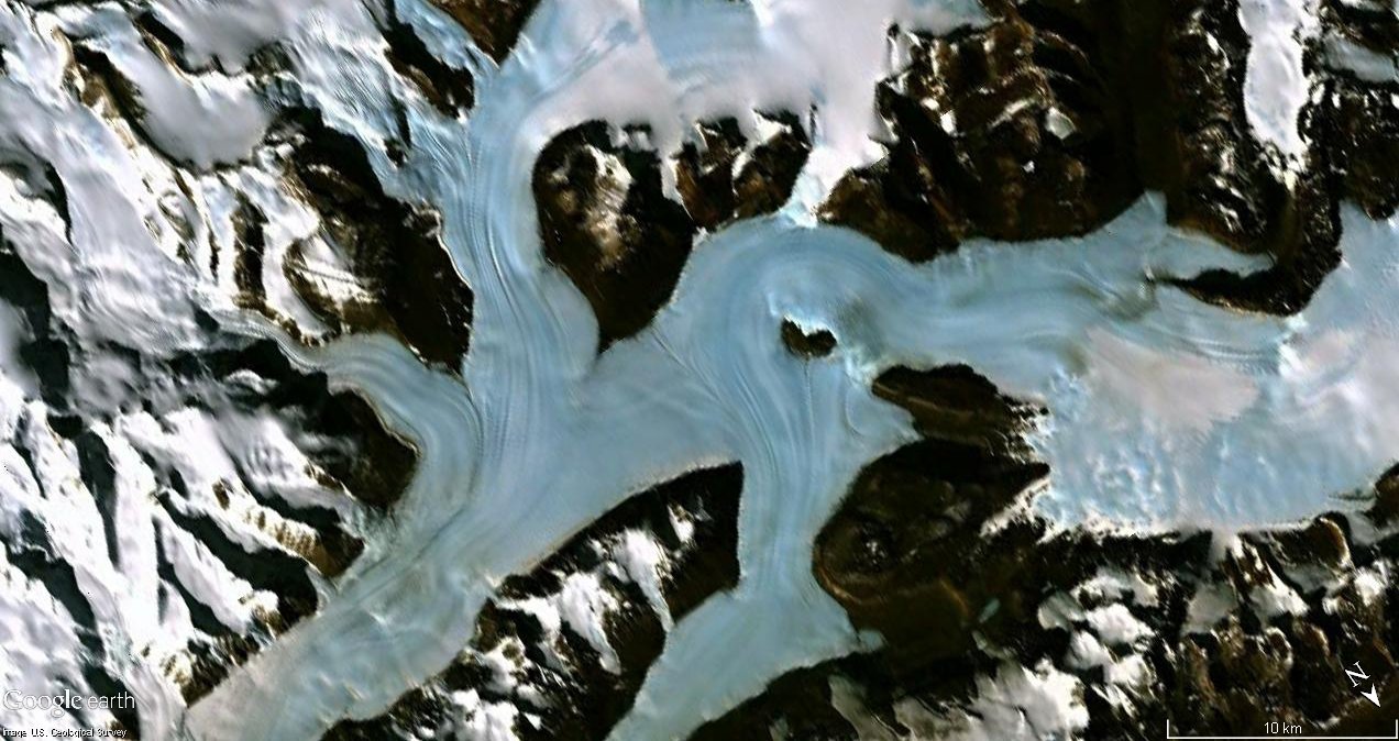
This week’s guess the planet image comes from Earth and
shows a region of Antarctica near the ross ice sheet. This image comes from Google
Earth, and if we look at a larger view of the same area we can see that the
glaciers flow down onto an ice shelf, which is breaking up into icebergs as it
meets the sea. The area is striking as we can see several large valleys separated
by rocky mountains. These valleys are covered by glaciers, and you can see
lines in the ice which indicate how it is flowing down between the mountains.
Several glaciers merge at the confluence of these valleys and you can see the
ridges where the streams of ice meet.

There is another region, not far from this part of Antarctica,
which doesn’t look as striking in aerial photographs, but which I want to talk
about as it is very significant for planetary science. This area is
characterised by a very different property to the wet and icy regions seen
above. This is the Antarctic dry valleys, the location of which are shown in
the map below. These valleys are of great interest to both Earth scientists and
those who study other planets. This is because; despite lying in ice locked Antarctica
they are one of the driest places on Earth. The cold conditions in this part of
Antarctica mean that there is very little precipitation, creating a cold desert
which is an excellent reference point for studying the cold, dry environments
of planets like Mars.

Unlike most of Antarctica the dry valleys are mostly free of
ice, and form a gravelly desert interspersed with polygonal patterned ground. This
landscape looks a lot like some of the polar regions of Mars and is thus a
prime candidate for analogue science. I’ve talked a lot about how similar
features recur from one planet to another. By understanding how something
evolves under terrestrial conditions we can extrapolate its behaviour on
another world. In order to do this effectively we first need to find good
counterparts for comparison. A lot of planetary science consists of comparing
the landscapes of other planets to known terrestrial features to see which familiar
landforms are the best fits. Sometimes we can do this in reverse.
In addition to studying the landscape of the dry valleys we
can look at their ecosystems as well. This is one of the most hostile places on
Earth, and so very little life survives here. The hardy species which have
evolved to occupy the dry valleys have very similar adaptations to those which
would be needed to survive on the cold, dry and salty surface of Mars.
Astrobiologists can study samples of these organisms, which are called “extremophiles”
because they like very extreme environments. Organisms are collected from very
cold or dry environments, and cultured in the lab. They can then be exposed to exaggerated
conditions, which more accurately simulate the environment of other planets. This
allows us to see whether they can evolve further to occupy a far more frigid
niche, or whether there are limits beyond which they become dormant or die off.
Almost every environment on Earth is inhabited by some sort
of organism, however they have an advantage over those which might be found on
other worlds. Terrestrial extremophiles can evolve from life forms that
originated in less hostile environments, but which became progressively hardier
as they moved into more dangerous climates. Many of these organisms could now
survive under martian conditions, at least to an extent, however it is less
certain that they could have evolved there from scratch. We thus need to
consider whether Mars harbours small areas which are warmer or wetter. These
would be more suitable for life to emerge and evolve, before expanding to
colonise the more hostile areas. This sends us back to our spacecraft data to
look at the landscape once more, and speculate as to which features of the
environment might by indicative of warmer climates.

For example we do see glacier like forms on Mars. This image
from HiRISE looks strikingly similar to the image of terrestrial glaciers above.
We see the same flow of material through a constricted valley and very similar
lines and bands. This doesn’t necessarily mean that it is a wetter environment,
there may not be any ice left in this martian glacier, as it could all have
sublimated long ago, leaving only the dust and debris which it deposited. Nonetheless
features like this are a clear indicator of the presence of large quantities of
ice at some point during their geological history, and hint at a dynamic
environment in the past if not the present. Check out the page for this HiRISE image which
has some more information about debris covered glaciers on Mars.
Image credits:
Antarctic glaciers via Google Earth
Map of the Antarctic dry valleys, USGS public domain image,
via Wikipedia

HiRISE image of martian glacier like form via Wikipedia.

Monday, 24 April 2017
Guess the Planet 27: Rocky
Here is this week's guess the planet image. What is going on in this rocky area, and which planet can it be found on?

Check back on Friday for the answer.

Check back on Friday for the answer.
Friday, 21 April 2017
Interpreting Barchan Dunes
This week’s image comes from Mars and is a CTX image of a
section of the large dune fields near the northern pole. These circumpolar
dunes form a sea of shifting sand, which encircle the northern icecap.
Different sections of the dune fields exhibit different types of dune patterns
and, as I’ve discussed before the shapes of dunes can tell us a lot about the local wind conditions.

This area is characterised by "barchan dunes". These crescent
like shapes are often found in terrestrial deserts as well. Barchan dunes form
when there isn’t enough sand to make a continuous blanket. It shifts from one
place to another, forming piles and mounds. the sparse barchans on the left hand side of the image gradually coalesce into more continuous ripples to the right. This suggests that there is less loose sandy material on the one side of the image and more on the other.
Barchan dunes generally occur in
places where the wind blows from a consistent direction, and so collects the
sand into crescent shaped mounds. The shape of the dune is the result of the
flow of air over it, giving them an aerodynamic shape. The points of the
crescent point downwind, so the structure of these dunes tells us what the
prevailing wind direction is.
The upwind face of the dune is generally shallower than the
downwind “slipface” which can be seen between the two horns of the dune. By measureing
these angles we can learn about the movement of granular material. We know that
the slip face will almost always be at the “angle of repose”. This is the
steepest angle at which a slope made of dry material remains stable. It cannot
become any steeper without collapsing, when the forces exerted on the slope
exceed the frictional forces keeping the grains of sand together.
The angle of repose depends on a lot of factors, including
the size and structure of the grains and the presence of water. Wet sand sticks
together more readily, as the water forms links between the sand grains. This can
come in handy when trying to build a sand castle, and allows a slope to form
which is steeper than the angle of repose would be for a dry granular material.
Thus if we know what the angle of repose of a slope should be at a site, we can
tell if a slope is steeper than expected, and thus must consist or wet sand or
a different material which is more stable. If it is shallower than expected
then we know that this slope is not yet at the angle of repose, and more
material can accumulate there before it risks becoming unstable.
But how do we determine what the expected angle of repose
should be? On earth this si quite well constrained for different materials,
although it can vary substantially from site to site. For a long time it has
been thought that the angle of repose was independent of gravity, and so the
same materials should form similarly steep slopes on any planet. However a
recent study has cast doubt on this.
Researchers set up a large number of rotating drums of sand
and gravel in an experimental aircraft and filmed them using high speed cameras
as they went through several parabolic flights in order to simulate different
levels of gravity. The results indicated that there were substantial changes to
the angle of repose due to changes in gravity. The paper itself can be found here, and this blog has a good overview of it for anyone who can’t
access the paper itself but wants more detail than is included in the abstract.
If these results are confirmed it could have some very
interesting implications for interpreting the geomorphology of other planets. Angle
of repose isn’t just significant when looking at sand dunes, but on any loose
slope, such as those on alluvial fans and mounds of debris. Figuring out how, and
if it changes with gravity could potentially give us a lot more information
about these landscapes.
Image Credit: NASA/JPL/University of Arizona, via Google
Mars
Monday, 17 April 2017
Guess the Planet 26: Crescents

What are these crescent shaped features, and where can they be found?
Friday, 14 April 2017
Combining Datasets

This week’s guess the planet image comes from Mercury and
was captured by the Messenger spacecraft using two separate instruments. These
are the Mercury Dual Imaging System (MDIS) which mapped the surface, and the Mercury
Laser Altimeter (MLA) which recorded the topography. I’ve talked before about some of the ways of producing topographic data from orbital spacecraft. In this case a somewhat different method has been used. The
instrument used a laser to record the distance between its orbital position and
the ground. Since the movement of the spacecraft is known very precisely it is
possible to time how long it takes a laser to reach the surface and derive distance
from this (since the speed of light is known).
Here this elevation data has been combined with the visual
data from the spacecrafts cameras. The result is a more useful and indeed more
impressive image than either instrument could generate on its own. The elevation
data has been used to create a perspective view across this part of mercury, so
that details of the positive and negative relief can be clearly seen. The false
colour component of the image shows the elevation, with reds indicating high
features and blue showing low elevation
areas. This is a fairly standard colour scheme for showing topography, and thus
allows us to interpret this landscape at a glance. More information about this area of mercury can be found at this link, to the NASA description of this image.
What we see is quite interesting. The area is clearly a
cratered plain, like much of Mercury. However there is a clear divide between
high elevation areas to the left of the image and lower elevation areas to the
right. The divide between these, which cuts across the central crater is the Carnegie
Rupes, a tectonic escarpment. “Rupes” means cliff or escarpment in Latin. This feature
is the result of the gradual shrinking of mercury. It is a small planet, only
slightly larger than Earth’s moon. As a result the core has cooled more rapidly
than that of Earth, and this has resulted in contraction of the planet. As the
planet shrinks a large number of faults and escarpments form as sections of the
crust get crinkled up.
By combining data from a variety of sources we can get a
good look at the structure of the cliff in this area. This allows us to
determine how and, in some cases, when it formed. For example in this location
the cliffs seem to cut through the basin of the Duccio crater. This tells us
that the crater must already have been present when the cliffs formed, and thus
that one feature is younger than the other. Planetary scientist rarely work
from isolated images, but compare and contrast between different datasets, and
use overlays like this to highlight features of the landscape. Any false colour
data can be combined with a visual map in order to make it clearer when
variations match other features. For example instruments which measure chemical
and mineral signatures on the surface can be combined with other data to
indicate where specific patches of materials occur, and whether they are frequently
associated with specific elements of the landscape.
All spacecraft carry a range of different sensors, and try
to collect as much diverse data on each orbit as they can. This is then
transmitted back to Earth and processed and combined by the scientists who
study that planet. The end result are higher level products such as this, which
can be used to study the planet, or demonstrate specific features of its
landscape.
Image Credit:
ASA/Johns Hopkins University
Applied Physics Laboratory/Carnegie Institution of Washington
Tuesday, 11 April 2017
Guess the Planet 25: Colour
Here is this week's (slightly delayed) guess the planet.
 What is this image and which planet does it show?

Subscribe to:
Posts (Atom)