
Monday, 30 January 2017
Guess the Planet 15: Blue Swirl
Here is this week's guess the planet. What is this feature, and where can it be found?

Friday, 27 January 2017
The Tallest Mountains

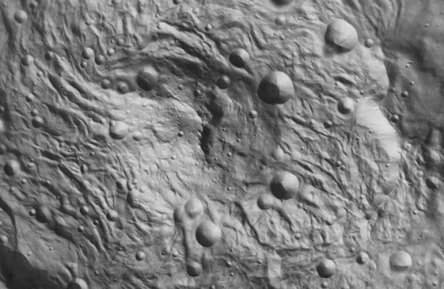
This week’s image shows part of the Rheasilvia basin. This large
impact crater covers much of the southern hemisphere of 4 Vesta, one of the
largest bodies in the solar system. This is one of the largest craters in the
solar system, and is one of the most prominent features on Vesta. The large
positive relief feature in the centre of the image is the craters central peak.
Central peaks are often found in very large impact craters, where the centre of
the crater rebounds to form an “uplift feature”. Large craters can exhibit a
variety of different uplift features, ranging from single peaks to complex structures
such as rings of peaks around the centre of the impact basin. More information
about types of crater can be found at this link.
The central uplift of Rheasilvia isn’t that complicated,
having only a single peal. However it is quite significant nonetheless. At 22
km it is the tallest mountain in the solar system. This may be surprising, as
for a long time this position had been held by the 21.9 km tall Olympus
Mons, the largest mountain on Mars. It wasn’t until the Dawn probe arrived at
Vesta in 2011 that the height of Rheasilvia’s central peak became apparent.
Despite being of similar height these mountains are very
different, because they formed in dramatically different manners. As discussed
above Rheasilvia formed as a result of rebound from the impact that created the
impact basin. Olympus Mons is a massive shield volcano, and formed gradually as
a result of numerous eruptions spewing lava onto the surface of Mars.
 |
| Olympus Mons |
Olympus Mons formed through the same process as the tallest
mountains on Earth, Mauna Loa and Mauna Kea on the large island of Hawai’i. These
shield volcanoes are 10.2 km tall, but the majority of their height is under
water. Even so they are far smaller than their martian counterpart, and one of
the main reasons for this is plate tectonics.
On Earth the tectonic
plates are constantly moving, rearranging the positions of islands and
continents as they gradually shift across the surface of the Earth. One of the
most striking expressions of this movement in the landscape can be seen in
strings of islands like those which make up Hawai’i. The Big Island on which Mauana
Kea and Mauana Loa are found is just the southernmost of an island chain. All of
these islands formed through volcanism, but not all of those volcanoes remain
active in the present day. These are just the tallest of a vast chain of
underwater mountains called the Emperor Seamounts which extend across the northern
Pacific Ocean.

These volcanoes formed above a “hotspot” in the Earth’s
mantle, where lots of very hot material wells up from deep within the planets
interior, causing extensive volcanism at the surface. Over time the pacific
plate has moved position, shifting the older mountains away from the centre of
the hotspot, and bringing a new area of seafloor to the point where volcanic
activity is strongest. Over time a chain of volcanic mountains forms, as new
volcanoes grow over the hotspot, before being moved away by continental drift.
Olympus Mons formed in much the same way, except that there
does not appear to be any plate tectonics on Mars. This means that the surface
of the planet isn’t moving relative to the hotspots in Mar’s mantle. Olympus
Mons stayed above the hotspot far longer than any of the mountains in the
Hawaii-Emperor seamount chain. It had more time to grow, and so is vastly
larger than its terrestrial counterparts.
Image Credits:
“Shaded-relief topographic map of Vesta southern hemisphere
showing two large impact basins. GSA Panel Presentation - Paul Schenk 2." Publicdomain image
3d view of Olympus Mons: courtesy of NASA, who also have some more information about Olympus Mons.
Map of the Hawaiian Islands based on NOAA data via Google Earth
Monday, 23 January 2017
Guess the Planet 14: Relief Feature
In this week's Guess the Planet, we'll take a look at this relief feature. What can we tell about this area from the landscape in this image? What solar system body is this found on? And why is it significant?

Friday, 20 January 2017
Stereo Images
This week’s guess the planet image comes from Mars, and on
this occasion I’ve chosen a feature related to my own research. This is a
HiRISE image of scalloped depressions near Peneus Patera in the southern hemisphere
of Mars. Credit goes to the NASA HiRISE team. This image is just under a kilometre
wide.

The depressions in this image are interesting for a number
of reasons. They are likely to form as a result of the sublimation of ground
ice. At this latitude on Mars there is frequently a thick layer of ice and
dust. When temperatures rise, during the martian summer, this ground ice can
sublimate, changing from a solid straight to a gas without the need to become
liquid first.
This results in the loss of a substantial volume of material
in the ground, leaving the large depressions seen in this image. You can see
that there are several edges in the larger image above, and that the ground is
littered with smaller pits, which have yet to form full depressions. The size
of these features suggests that a lot of water ice must once have been in the
ground here. So how would you go about working out the volume of material (both
dust and ice) which has been lost?
One technique which planetary scientists use to determine
depth is to look at the length of shadows. We know the time of day at which any
image is taken, and thus the height of the sun in the martian sky at that time.
This means that if we have some clearly defined shadows in an image we can use
some simple trigonometry to work out the height of the feature casting them.
Unfortunately in this case there aren’t any particularly
good shadows to use. The steep slopes are all on the northern edge of the
feature, which is quite irregular due to its scalloped shape. Furthermore these
features have an asymmetric profile. The pole facing slope (in this case the
one at the top of the image) is typically very steep, while the equator facing
slope is much shallower. This all means that there aren’t any particularly good
shadows to measure.
Fortunately we have another tool at our disposal, a second
image of the same area. With this it is possible to actually create a 3d model
of the site. When we see things, our eyes each receive a slightly different
view of whatever we are looking at. The slight differences between what each
eye is seeing are interpreted by the brain as a 3d image. We can do the same
thing with a computer, by comparing the differences between two images to
figure out the real shape of the objects being imaged.
This is similar to how a 3d film is made. Filmmakers use two
cameras simultaneously, a process which goes right back to the 19th
century when “stereoscopic photographs” were all the rage. In our case we need
to wait for the spacecraft to pass over the site again, and take a second image
from a slightly different angle. This was done for this site, creating what is
called a stereo pair between this image and PSP_005698_1225.
By putting the two images
together, and doing a lot of painstaking processing, we can not only produce a
3d image, but what is called a “digital terrain model”. This is a 3d map of the
area, which will show us the height of the walls of the depressions as
determined by the differences between the two images. We can use models like
this to make very precise measurements of height and depth.
 Hopefully some of you
reading this have a pair of the 3d glasses with the red and blue lenses. If so
take a look at this image, which is called an “anaglyph”. Here the two offset
images have been combined, with each having a different colour. The coloured
lenses in the glasses allow each eye to look at a different image, and trick
the brain into seeing it in 3d. Obviously this isn’t as good for making precise
measurements, but can give you a better sense of the landscape than you would
get from a flat image.
Hopefully some of you
reading this have a pair of the 3d glasses with the red and blue lenses. If so
take a look at this image, which is called an “anaglyph”. Here the two offset
images have been combined, with each having a different colour. The coloured
lenses in the glasses allow each eye to look at a different image, and trick
the brain into seeing it in 3d. Obviously this isn’t as good for making precise
measurements, but can give you a better sense of the landscape than you would
get from a flat image.
Image Credit: NASA/JPL/University of Arizona HiRISE image
PSP_004274_1225 http://www.uahirise.org/PSP_004274_1225
Anaglyph Credit: NASA/JPL/ University of Arizona
http://hirise-pds.lpl.arizona.edu/PDS/EXTRAS/ANAGLYPH/PSP/ORB_004200_004299/PSP_004274_1225_PSP_005698_1225/PSP_004274_1225_PSP_005698_1225_RED.browse.png
Monday, 16 January 2017
Guess the Planet 13: Edge

Friday, 13 January 2017
The Discovery of the Asteroid Belt

This week’s
guess the planet image is a type of solar system object we’ve not covered
before. This is an image of the Asteroid 234 Ida. It comes from a close approach
by the NASA Galileo spacecraft in 1993, and credit goes to the NASA Jet
Propulsion laboratory. More information about how this image was acquired can
be found at this link. Interestingly the Galileo team didn’t know precisely
where the asteroid was located prior to the close approach, so this image is
made up of five frames out of 30 which were taken in this region of space, to
make sure that the asteroid was imaged.
Asteroids are
found throughout the solar system, but one of the largest groupings is the
asteroid belt between Mars and Jupiter, which is where 234 Ida is located. This
is quite an interesting region of space, as it contains a very large number of
bodies, including the dwarf planet Ceres.
The asteroid
belt was discovered as a result of a peculiar phenomenon called the Titius-Bode
Law. During the eighteenth century astronomy was taking off. One issue that
intrigued the early astronomers was whether there were other planets beyond the
six which had been known since antiquity. They were looking for patterns in the
skies, and a German astronomer named Johann
Daniel Titius seemed to have found one.
He observed a pattern in the distribution of the known planets, namely
that each planet was approximately twice as far from the sun as the previous
one. He was able to derive a mathematical relationship which seemed to describe
the precise positions of the planets, but there was a gap in the sequence.
Titius’ model predicted that there should be a planet in what is now
known to be the orbit of the asteroid belt. This gave the astronomers of the
day somewhere to start looking, and it wasn’t long before they discovered
Ceres, and later the other large asteroids. It seemed as though this law could
be used to derive the locations or further planets, and astronomers began searching
for further objects in the outer solar system, ultimately discovering Uranus in
pretty much the location predicted by the law. Unfortunately there was no
physical reason why the distribution of the planets should fit this pattern.
It wasn’t until the discovery of Neptune, in an entirely different
location to that predicted by Titius, that faith in the law began to fade. The discovery
of further dwarf planets, which also don’t fit the model, has provided further
proof that the supposed relationship was coincidental. The Titius-Bode law has
now been thoroughly discredited, but it played an important role in the
discovery of some of the most interesting objects in the solar system.
It is possible that this pattern
evolved from the orbital resonances caused by the interactions of the planets. Large
planets influence the orbits of their neighbours, and can create regions where planets
do not easily form, and stable orbits cannot occur, since the motion of objects
there is gradually perturbed by contact with its neighbours.
This brings us back to the asteroid belt. It was initially thought that
the asteroids might be the remnants of a planet which had been destroyed by a catastrophic
impact. However this doesn’t seem to be the case. Almost all of the mass of the
asteroid belt is found in the four largest bodies, and there isn’t sufficient
mass to produce a large planet.
It seems more likely that the gravitational effect of Jupiter prevented
the formation of a planet in this region of space, stopping the various
planetesimals from coalescing into a larger body. This is supported by the variety
of compositions found across the asteroid belt. Different objects are made up
of different materials. Silicaceous or stony asteroids like Ida are composed primarily
of rock, while others have a more metallic composition.

One metallic asteroid is 216 Kleopatra, which was imaged using radar signals from the Aricebo Observatory. Most asteroids are fairly irregular in shape, with very few being anywhere near spherical. This body takes this to an extreme, as it is made up of two very distinct sections, separated by a narrow section. This is believed to be a “contact binary”, it was once two separate objects, but they were drawn together by their mutual gravity and merged into a single object. These kinds of collisions and mergers aren’t particularly common in the asteroid belt, as objects there are so spread out. However as the impact craters on Ida attest collisions do occur, and can result in some very interesting shapes.
Image Credits: NASA/JPL
234 Ida: http://photojournal.jpl.nasa.gov/catalog/PIA00135
216 Kleopatra: http://nssdc.gsfc.nasa.gov/planetary/news/kleopatra_pr_20000504.html
Monday, 9 January 2017
Guess the Planet 12: Light and Dark
Cratered surfaces are pretty common across the solar system, but why is half of this image in shadow, and what solar system body does it show?
 Find out more in Friday's post.

Friday, 6 January 2017
Pluto's Icy Plains

This week’s guess the planet image comes from Pluto. This is
a close up image of the icy region of Sputnik Planitia. This image was taken by
the New Horizons spacecraft, and so credit goes to NASA’s New Horizons team.
The full image is 80 km wide and 700 long. NASA describes it as “trending from
the northwestern shoreline of Sputnik Planum and out across its icy plains.” They
also note that this image was taken just before the New Horizons probe’s
closest approach to Pluto, making it among the highest resolution images we
have from this body. The space craft has been observing Pluto for some time as
it approached the distant world, but only had a short period during the closest
approach of its flyby, when it was possible to acquire the most detailed
images.
Some spacecraft are put into orbit around the planets they
survey, and so can operate for years, returning thousands of images with
similarly high resolutions, however this isn’t always possible. For the New
Horizons probe getting into orbit wasn’t an option due to the high speed
required to travel to Pluto. New Horizons set off from Earth moving faster than
any previous space probe. Once out in space it becomes very difficult to slow
down, as doing so involves expending a vast amount of fuel. There was no way
for the New Horizons probe to carry enough fuel for it to slow down and enter
the orbit of Pluto. Instead it was set up to be a “fly by” mission, intended to
cram as many observations as possible into the very brief period when it was at
its closest approach.
The New Horizons team delivered some amazing images of the
distant dwarf planet, which has given us our first good look at its surface and
geography. One of the most striking features of Pluto is a bright heart shaped
region which was entirely unknown prior to this mission. Sputnik Planitia forms
one lobe of this heart shaped region, and was named after the first man made satellite.

“Planitia” is Latin for plain, and so denotes a wide open
area. The term “Planum” is also sometimes used. The dominant feature of this
plain is a series of polygonal cells, which can be seen as bright hexagonal bands
criss-crossing the image. These are thought to be evidence of convection in the
ice that covers this region. This isn’t water ice, like that found on Earth,
but rather made of nitrogen and carbon monoxide. These substances are only
found as gasses on earth, but on Pluto it is cold enough for them to exist in the
solid state. However they remain reasonably dynamic, moving on long timescales.
In some ways this environment is analogous to a terrestrial ice
sheet. On Earth mountains of rock are eroded by flows of slowly moving water
ice, called glaciers, which build up at the heads of valleys over many years. This
slow moving ice carves up the stone, creating wider valleys. In some places
vast ice sheets extend across the continent, as they did across much of the
northern latitudes of Earth during the last ice age.
On Pluto the process is the same, but the materials are very
different. Here the hard water ice takes the place of the rock, and the softer
nitrogen ice behaves in the same ways that water ice would on Earth. Some
glacier like structures have been spotted at the edge of Sputnik Planitia where
the water ice mountains are carved by these flows. Away from the edges of the
plain the ice is free to convect, slowly churning and creating the polygonal
shapes visible in the image. The rippled and pitted texture of the ice is likely due to sublimation. The upper layer of ice turns back into gas in some places, forming irregular chains of pits and troughs.
We are still only scratching the surface of Pluto’s
geography, but the new data from this mission are already shedding light on how
this distant dwarf planet works.
Image Credits: NASA/JHUAPL/SwRI
The full image of Sputnik Planitia is too long to post here, but can be seen in all its glory on this NASA page: https://www.nasa.gov/image-feature/pluto-s-icy-plains-in-highest-resolution-views-from-new-horizons
More information about ice flow on Pluto can be found here: https://www.nasa.gov/feature/new-horizons-discovers-flowing-ices-on-pluto
Subscribe to:
Posts (Atom)